2026 edition · 17 of these 44 roads shut for winter from late October€26.99, once
Out for aDriveRoadbooks
ENDEBuy this book
Roadbooks  /  Switzerland Roadbook 2026
Out now · 2026 season

Switzerland Roadbook 2026

Switzerland, the passes and the roads either side of them

44 driving roads across Switzerland, with the crossings into Italy, France, Austria and Germany that a Swiss week ends up on, one page each: what the road is like to drive, when the canton opens the gate, what you may not take up it, up to four places worth stopping for, and a button that opens the whole route in Google Maps. 1,017 km of road, every line drawn from OpenStreetMap and measured at both ends against the places its page names.

30-day refundDrive one road out of it. If it was not worth the Saturday, one line gets the €26.99 back and you keep the files.
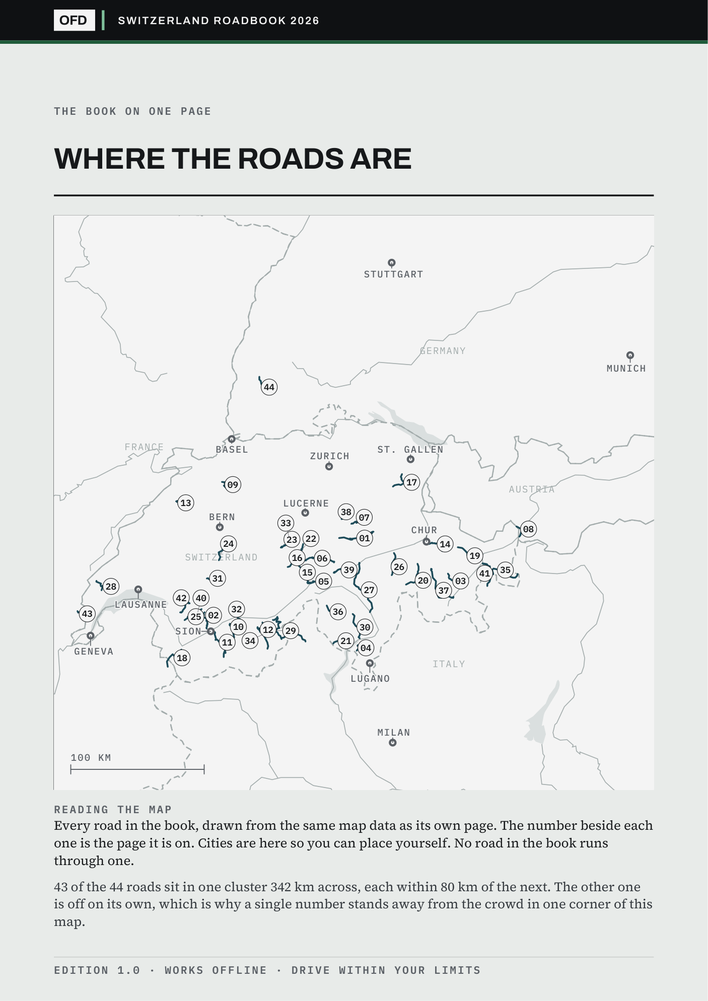
Page 2 of 44 · the key map44 roads
Page 2 of the book: every road on one plate, each marked with the page it is on, over country outlines
All 44 roads on one key map, each marked with its page. Drawn from OpenStreetMap. No photography.
Switzerland Roadbook 202644 roads · 1,017 km
€26.99Buy this book
44
Roads, one A4 page each
1,017 km
Measured on each road's own track
44
GPX tracks, one per road
135
Stops checked one by one, 41 left blank rather than guessed
Stage 01What page 01 does

The book opens on its best road, and prints what stands between you and it.

The Klausen Pass scores 10.0, the highest in Switzerland, and it is page 01 because the book is ordered by country and then by score. Its page prints what stands between you and the road, which here is 2.30 m limit, and names the authority that says so at the foot.

Every other page is built the same way: the gate, the season, the measured distance and the source, before any adjective.

Roads marked shut
0 of 44
Roads with a toll
0 of 44
Facts without a source
none
Page 01 of 44 · as it printsOpen
Klausen Pass
Uri / Glarus · 46.1 km · score 10.0
2.30 m limit
Access2.30 m limit
Route linkopens the whole road in Google Maps
GPX trackshipped
Source: alpen-paesse.ch/en/alpenpaesse/klausenpass; 2.30 m and 18 t free, 2.55 m by permit weekdays; closure 13.09.2026 10-16; Schlierenegg lights to October 2026); alpen-paesse.ch/en/alpenpaesse/klausenpass (1,948 m, 35 km, 9 per cent, 02.05-31.10.2026, printed at the foot of the page itself.
Stage 02The anatomy of one page · press it yourself

Seven things on every road's page.

01The drive scoreOut of ten, from corners, scenery and a traffic penalty. The formula is printed so you can disagree with it precisely.
02What stands between you and the roadA ban with dates, a barrier, a landslide closure or a toll, whichever it is, with the body that issues it.
03When the gate opensFirst and last admission, and the months the road is shut for winter.
04The distance, measuredTaken off the road's own GPX track, not copied from a tourist board.
05Up to four stopsEach checked one at a time. An empty slot stays empty rather than being filled with a guess.
06Drive the routeOne press opens the whole road in Google Maps, corner for corner, not just the start point.
07The sourceNamed at the foot of the page, so every number on it can be checked.
Page 05 of 44 · Furka PassLive · offline

Scroll it, press it. This is the page as it is in the book, at phone size.

Stage 03Before you pay · is it near you

Where these roads are, measured from where you start.

Lucerne has 41 of the 44 roads inside 150 km; Munich has none, and its nearest road is 157 km away. If you drive out of a city with many, this book is dense with Saturdays. If you drive out of one with none, it is a holiday purchase, and you should know that before you pay rather than after.

Every number is a straight line from the city to the nearest point of each road's own track, and the cities with none are printed alongside the cities with many.

Check your own town in the free sample
Starting fromWithin 150 kmNearest road
Lucerne41 roadsnearest 21 km
Zurich39 roadsnearest 41 km
Lugano38 roadsnearest 14 km
Bern37 roadsnearest 16 km
Stuttgart1 roadnearest 132 km
Munichnonenearest 157 km
Six starting cities, measured in a straight line to the nearest point of each road's own track. The offline page re-sorts every road from whichever town you type into it.
Stage 04The index · check my work before you pay

Two of the 44, with their sources printed.

Both ends of what this book does: a road where what stops you is trailer ban and a road where what stops you is shut sat-sun. Both carry the source of every figure on them, so a toll or a gate time can be checked before you spend anything. The free sample is the same two files cut to five roads, and it opens and closes on exactly these two.

PgRoadRegionLengthScoreAccess
05Furka PassUri / Valais · 22.6 kmUri / Valais22.6 km9.3Trailer ban
07Pragel PassSchwyz / Glarus · 22.5 kmSchwyz / Glarus22.5 km9.1Shut Sat-Sun
The other 42 are in the book.
Same page, same sources, one per road. Or take five roads free and check these two first.
Buy all 44 · €26.99
Stage 05Read this before you buy

What this book does not claim.

Somebody who read an early copy came away believing I had driven them all. I had not, and nothing in that copy had said so plainly enough. Three limits, each one open to read in full.

What €26.99 buys is desk research done properly and shown working: every fact carries its source, and the roads I could not verify say so on their own page.

01The book is in English

The road names print as the signs spell them, in German, French, Italian and Romansh; the prose is English.

02Nine famous Swiss passes are in the Northern Italy book, not this one

The Gotthard and the Tremola, the Bernina, the Great St Bernard, the Umbrail, the Maloja, the Splügen, the San Bernardino, the Nufenen and the Forcola di Livigno all cross into Italy, and they are pages in that book. Nothing is printed twice: buy both and you have the Alps whole.

03You still need the vignette

Almost nothing in this book charges for the road itself, but the motorway sticker that gets you to most of them costs 40 francs a year and the fine for not having one is 200. That is the only money the book assumes you will spend.

The price

€26.99, once. All 44 roads, yours to keep.

One download of the 2026 edition, licensed to one person on any number of your own devices. No subscription, no account, no login. Find something wrong in it and it is fixed in the next edition. Buying this book does not commit you to the rest. All four books together are €79.00.

VAT included · checkout on Stripe · link by email in a minute
Refund within 30 days, one line, no reason needed, and you keep the files

What arrives
Switzerland-Roadbook.pdf44 road pages
Switzerland-Start-Here.htmloffline, one tap
gpx/44 tracks
Licenceone person, your devices
Page colour