Driving guide · digital download · Edition 2027
Germany and Austria Driving Guide
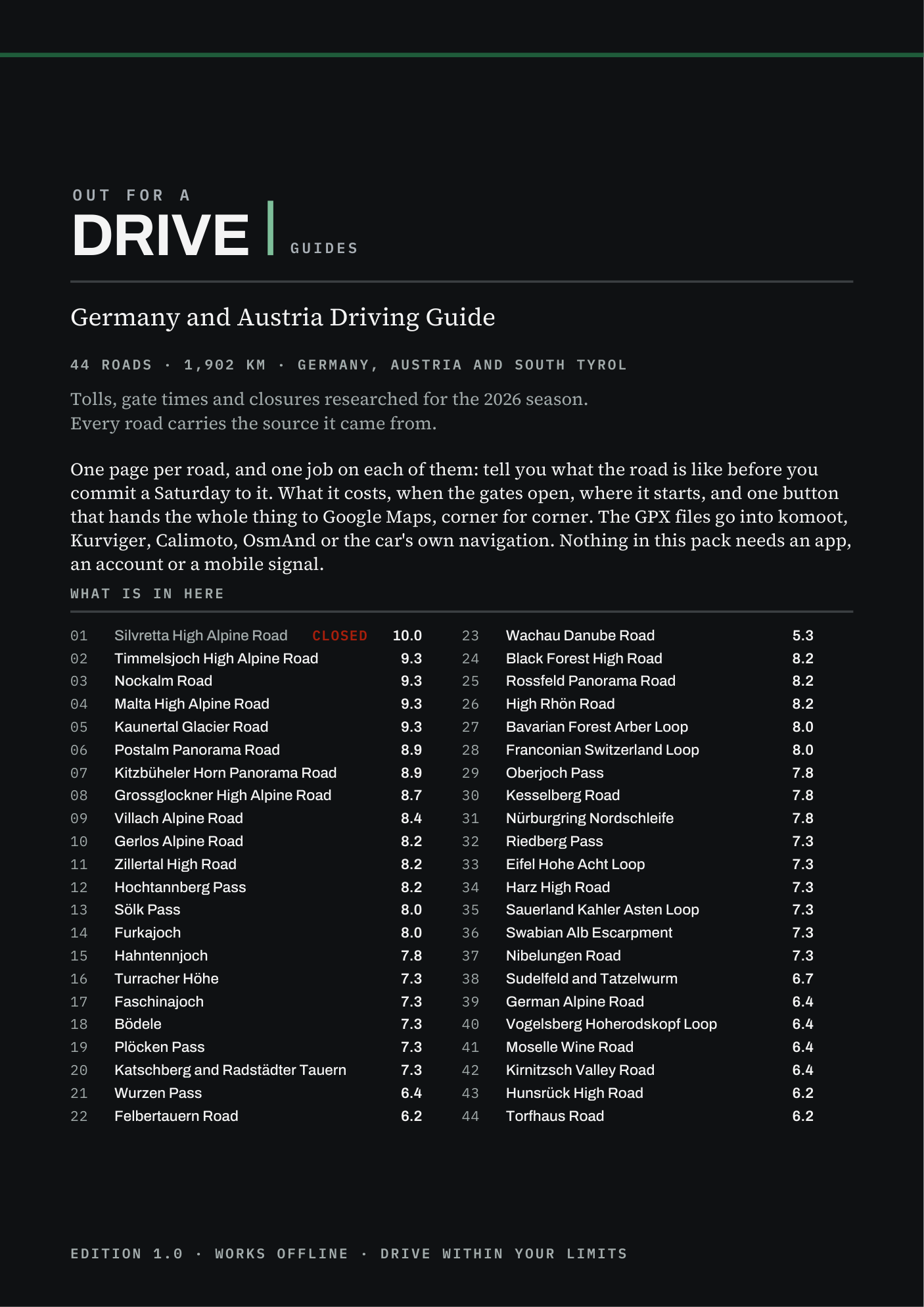
44 driving roads · Germany and Austria. One page each, with the route, the toll, the season and where to stop.
- Roads
- 44
- Total length
- 1,902 km
- GPX
- 43
- Toll roads
- 13
One road is shut, so it ships no GPX track.
- The PDF, the Start Here page for your phone (works offline, sorts the roads by distance) and 43 GPX tracks
- Download link by email in a minute. Card, Apple Pay, Google Pay
- Refund within 30 days, no reason needed
- The guide is in English
- Edition 2027: the rechecked edition is emailed to you free by 1 May 2027
Written and published by Tom Sonecki, a sole trader (Einzelunternehmen) in Hamburg. Payment by Stripe, which is the merchant of record.
Why this guide
Here the gate is a toll booth and a closing time. One road has a barrier instead, and every list still recommends it.
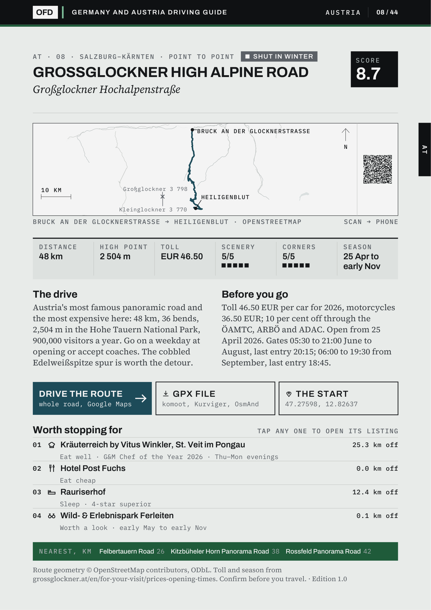
44 driving roads across the Alps, the pre-Alps and the German uplands, one page each: what the road is like to drive, the 2026 toll, when the gate opens and when it shuts, up to four places worth stopping for, and a button that opens the whole route in Google Maps. 1,902 km of road, every line drawn from OpenStreetMap, and every toll printed with the page it was read from.
If you came here looking for the Denzel: the Große Alpenstraßenführer closed with its 28th edition in 2021 and is out of print. This guide is not it, and it does not rate roads by difficulty. It is one page per road with the 2026 toll, the gate hours and a route that opens on your phone.
The 2026 toll, with its source beside it
The Grossglockner is €46.50 a car for summer 2026 and lets the last car in at 20:15 in high summer and 18:45 from September; the Timmelsjoch is €20.00 one way, charged on the Austrian side only; the Nordschleife is €30.00 a lap, Monday to Thursday. Each figure was read from a published page, the operator's own for most of them, and that page is named beside it. Where a price cannot be confirmed the cell prints blank rather than a guess.
One road is shut, and the guide opens on it
The Silvretta High Alpine Road has been closed since a rockfall in July 2024 and reopens in 2030 at the earliest. It scores 10.0, it is still first in every search, and it is road 01: its page tells you not to drive it, ships no route link and no GPX track, and names the Hochtannberg Pass, 33 km away and open, instead.
Up to four places worth stopping for
Somewhere to eat well, somewhere to eat cheaply, somewhere to sleep and something worth a look: up to four on each road, each measured against the road's own track. Where nothing could be confirmed the slot is left empty, a place whose hours are not confirmed says so, and the guide's last page counts how many were checked as still trading. The Werkraum Bregenzerwald prints on four Vorarlberg roads because it is within 25 km of all four. Nothing here is paid for or affiliated.
Page 2 of the guide
Check it is your region before you pay.
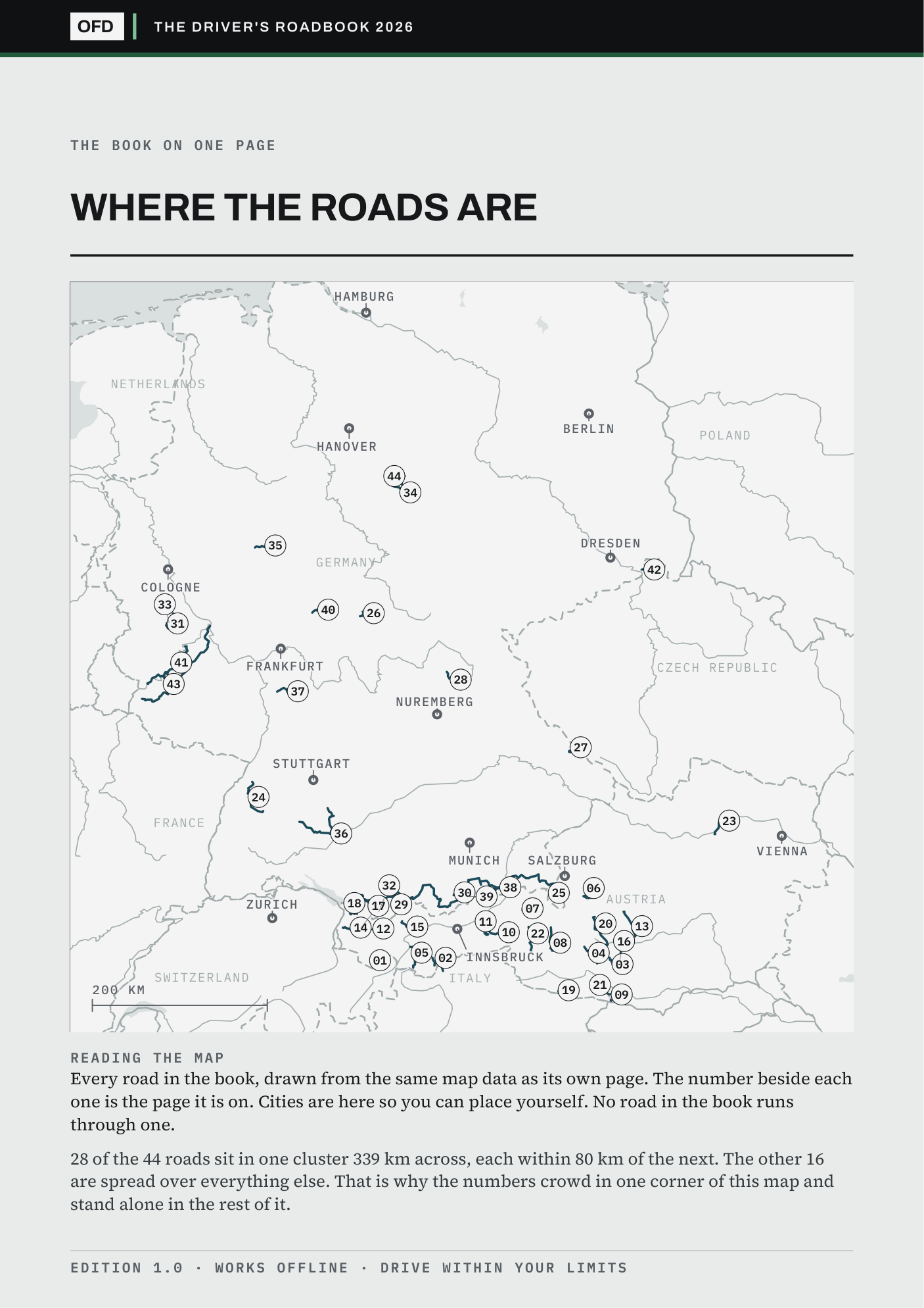
Straight-line distance from each city to the nearest point of each road. The free sample carries this whole map.
| City | Roads within 150 km | Nearest |
|---|---|---|
| Innsbruck | 21 | 27 km |
| Salzburg | 19 | 13 km |
| Munich | 16 | 41 km |
| Zurich | 11 | 82 km |
| Frankfurt | 8 | 45 km |
| Cologne | 5 | 50 km |
| Berlin | 0 | 186 km |
| Hamburg | 0 | 189 km |
Not your region? The shelf sorts all seven guides by the roads near your town.
The contents
Every road in the guide.
free in the sample
| No. | Road | Region | Toll or gate | Season |
|---|---|---|---|---|
| 01 | Silvretta High Alpine Road free | Vorarlberg / Tirol | Shut until 2030 at the earliest | Closed |
| 02 | Timmelsjoch High Alpine Road | Tirol / Alto Adige | EUR 20.00 | Seasonal |
| 03 | Nockalm Road | Kärnten | EUR 25.00 | Shut in winter |
| 04 | Malta High Alpine Road | Kärnten | EUR 25.00 | Shut in winter |
| 05 | Kaunertal Glacier Road | Tirol | EUR 32.00 | Open all year |
| 06 | Postalm Panorama Road | Salzburg | EUR 14.00 | Open all year |
| 07 | Kitzbüheler Horn Panorama Road | Tirol | EUR 25.00 | Shut in winter |
| 08 | Grossglockner High Alpine Road free | Salzburg / Kärnten | EUR 46.50 | Shut in winter |
| 09 | Villach Alpine Road | Kärnten | EUR 23.50 | Shut in winter |
| 10 | Gerlos Alpine Road | Salzburg / Tirol | EUR 13.00 | Open all year |
| 11 | Zillertal High Road | Tirol | EUR 10.00 | Shut in winter |
| 12 | Hochtannberg Pass | Vorarlberg / Tirol | No toll | Open all year |
| 13 | Sölk Pass | Steiermark | No toll | Shut in winter |
| 14 | Furkajoch | Vorarlberg | No toll | Shut in winter |
| 15 | Hahntennjoch free | Tirol | No toll | Shut in winter |
| 16 | Turracher Höhe | Kärnten / Steiermark | No toll | Open all year |
| 17 | Faschinajoch | Vorarlberg | No toll | Open all year |
| 18 | Bödele | Vorarlberg | No toll | Open all year |
| 19 | Plöcken Pass | Kärnten | No toll | Open all year |
| 20 | Katschberg and Radstädter Tauern | Salzburg / Kärnten | No toll | Open all year |
| 21 | Wurzen Pass | Kärnten | No toll | Open all year |
| 22 | Felbertauern Road | Tirol / Salzburg | EUR 13.50 | Open all year |
| 23 | Wachau Danube Road | Niederösterreich | No toll | Open all year |
| 24 | Black Forest High Road free | Baden-Württemberg | No toll | Open all year |
| 25 | Rossfeld Panorama Road | Bayern | EUR 9.50 | Open all year |
| 26 | High Rhön Road | Bayern / Hessen | No toll | Open all year |
| 27 | Bavarian Forest Arber Loop | Bayern | No toll | Open all year |
| 28 | Franconian Switzerland Loop | Bayern | No toll | Open all year |
| 29 | Oberjoch Pass | Bayern | No toll | Open all year |
| 30 | Kesselberg Road free | Bayern | No toll | Open all year |
| 31 | Nürburgring Nordschleife | Rheinland-Pfalz | EUR 30.00 | Shut in winter |
| 32 | Riedberg Pass | Bayern | No toll | Open all year |
| 33 | Eifel Hohe Acht Loop | Rheinland-Pfalz | No toll | Open all year |
| 34 | Harz High Road | Niedersachsen / Sachsen-Anhalt | No toll | Open all year |
| 35 | Sauerland Kahler Asten Loop | Nordrhein-Westfalen | No toll | Open all year |
| 36 | Swabian Alb Escarpment | Baden-Württemberg | No toll | Open all year |
| 37 | Nibelungen Road | Hessen / Bayern | No toll | Open all year |
| 38 | Sudelfeld and Tatzelwurm | Bayern | No toll | Open all year |
| 39 | German Alpine Road | Bayern | No toll | Open all year |
| 40 | Vogelsberg Hoherodskopf Loop | Hessen | No toll | Open all year |
| 41 | Moselle Wine Road | Rheinland-Pfalz | No toll | Open all year |
| 42 | Kirnitzsch Valley Road | Sachsen | No toll | Open all year |
| 43 | Hunsrück High Road | Rheinland-Pfalz | No toll | Open all year |
| 44 | Torfhaus Road | Niedersachsen | No toll | Open all year |
Questions
Anything else: info@outforadrive.com
What does Edition 2027 mean?
You download the current guide the moment you pay, with every toll, gate hour and opening date as read for the 2026 season. Each is then checked again for 2027, and the rechecked edition is emailed to you free by 1 May 2027. The roads, routes and GPX tracks do not expire. Every guide, in the 2027 Edition (all seven guides in one checkout) or bought on its own, gets its rechecked edition this way.
Why does one road have no GPX track?
The Silvretta is shut until 2030 at the earliest. A track that ends at a barrier is worse than no track, so the page carries none and no route link either, and says so.
What if a road is shut when I go?
Every page prints the road's season. Where the season has dates, the Start Here page on your phone checks today's date and says whether the road is open now, shut for winter, or which month it opens.
Is this not free on Google Maps?
The roads are on every map, and the route lines here come from OpenStreetMap, which is free too. What is not free is the day it takes to find out that the Silvretta High Alpine Road is shut until 2030 at the earliest, what each road charges and when its gate closes, and which places near it are worth the stop, with any not yet confirmed marked as such. That is the work in every page, and each page says where its answers came from.
Does it work with my navigation app?
The GPX tracks load into komoot, Kurviger, Calimoto, OsmAnd and Garmin. If your car's own navigation cannot import a GPX file, tap Drive the route on the page: the whole road opens in Google Maps on your phone, and from there on CarPlay or Android Auto. Apple Maps and Waze get the start of the road.
Is it for motorcycles too?
Yes. The roads are the same on two wheels, and where an operator bars motorcycles, the road's own paragraph says so. Nine of the 13 toll roads print the motorcycle toll beside the car's; for the others, check the operator's page.
Is this a printed book?
No. It is a download: an A4 PDF with one page per road, a Start Here page for your phone that works with no signal, and a folder of GPX tracks. Print the PDF on a home printer if you want paper.
Can I give it as a present?
Yes. Buy it as usual, then write to info@outforadrive.com with the name and email address of the person it is for. A download link of their own is emailed to them, the licence passes to them, and the rechecked 2027 edition goes to their address too. Fresh links from the re-download page still go to the address you paid with.
What if it is not for me?
Ask for a refund within 30 days. One line is enough, and no reason is needed.
The 2027 Edition
This guide and six more for €79.00.
All seven cost €188.93 bought one by one. The 2027 Edition is one checkout for all of them and for every guide published while the 2027 Edition is on sale.
Every guide, in the Edition or bought on its own, gets its rechecked 2027 edition free by email.


