66 driving roads across Poland, Czechia and Slovakia - the Tatras and the Beskids, the Bieszczady, the Sudetes and the Table Mountains, the Jeseníky and the Krkonoše, the Šumava and the Ore Mountains, the Low Tatras and the Slovak Karst - one page each: what the road is like to drive, who holds the gate and on what terms, what you may not take up it, up to four places worth stopping for, and a button that opens the whole route in Google Maps. 1,451 km of road, every line drawn from OpenStreetMap and measured at both ends against the places its page names.

The The Wielka Pętla Bieszczadzka scores 9.3, which nothing in Poland beats, and it is page 01 because the book is ordered by country and then by score. Its page prints what stands between you and the road: the third cell reads “Paid parking”, and the foot of the page names the body that says so.
Every other page is built the same way: the gate, the season, the measured distance and the source, before any adjective.
Scroll it, press it. This is the page as it is in the book, at phone size.
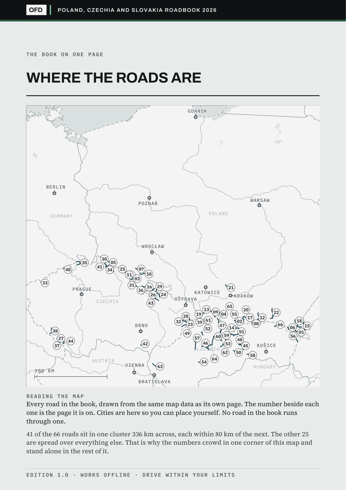
Ostrava has 34 of the 66 roads inside 150 km; Gdańsk has none, and its nearest road is 426 km away. If you drive out of a city with many, this book is dense with Saturdays. If you drive out of one with none, it is a holiday purchase, and you should know that before you pay rather than after.
Every number is a straight line from the city to the nearest point of each road's own track, and the cities with none are printed alongside the cities with many.
Check your own town in the free sampleBoth ends of what this book does: a road where whose third cell reads “Barrier off it” and a road where nothing stands between you and it. Both carry the source of every figure on them, so a toll or a gate time can be checked before you spend anything. The free sample is the same two files cut to five roads, and it opens and closes on exactly these two.
Somebody who read an early copy came away believing I had driven them all. I had not, and nothing in that copy had said so plainly enough. Four limits, each one open to read in full.
What €26.99 buys is desk research done properly and shown working: every fact carries its source, and the roads I could not verify say so on their own page.
The road names print as the signs spell them, in Polish, Czech and Slovak, with every mark on them; the prose is English.
All three countries keep their driving roads along one arc, from the Sudetes to the Bieszczady, and this book follows it. Ostrava has 34 of these roads within 150 km, Kraków 33, Katowice 31, Košice 25, Brno 17, Wrocław 16, Prague 15. Gdańsk has none within 300 km and its nearest is 426; Warsaw, Poznań and Berlin have none within 150. If you live in the north this is a holiday book and not a Sunday one, and the free sample draws all 66 on one map so you can see that before you pay.
Every other book in this series has forty-four. This one has 66 because it is three countries with three separate sets of mountains, and forty-four would have meant leaving out the Šumava or the Slovak Karst or the Bieszczady altogether. The split between the three followed the roads rather than a quota.
Morskie Oko, the Dunajec gorge road and Kráľova hoľa are all shut to private cars, and the book says so on the page of the road that passes their turning rather than quietly leaving them out.
One download of the 2026 edition, licensed to one person on any number of your own devices. No subscription, no account, no login. Find something wrong in it and it is fixed in the next edition. Buying this book does not commit you to the rest. All six books together are €79.00.
VAT included · checkout on Stripe · link by email in a minute
Refund within 30 days, one line, no reason needed, and you keep the files