Driving guide · digital download · Edition 2027
Spain and Portugal Driving Guide
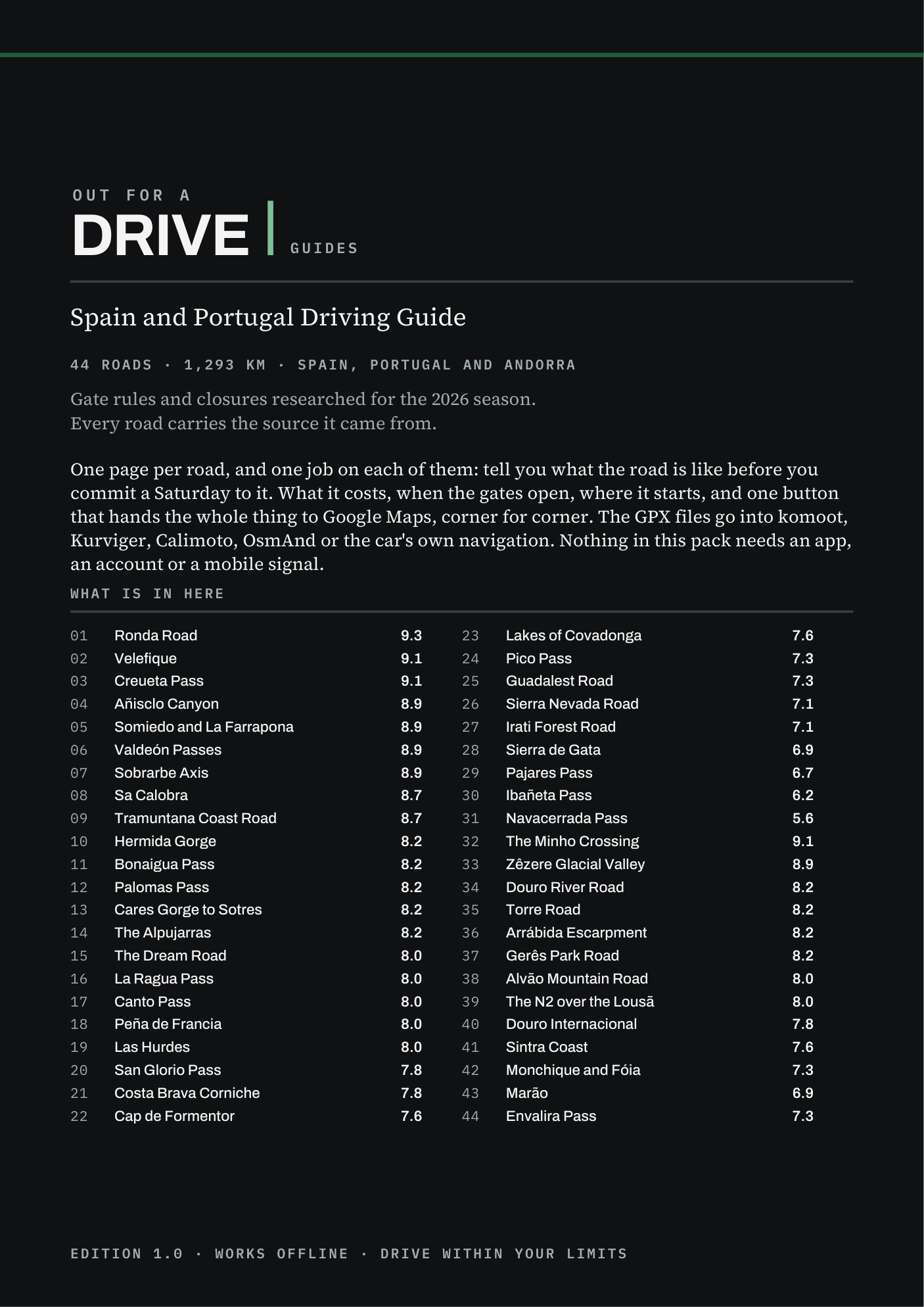
44 driving roads · Spain and Portugal. One page each, with the route, the toll, the season and where to stop.
- Roads
- 44
- Total length
- 1,293 km
- GPX
- 44
- Toll roads
- 0
- The PDF, the Start Here page for your phone (works offline, sorts the roads by distance) and 44 GPX tracks
- Download link by email in a minute. Card, Apple Pay, Google Pay
- Refund within 30 days, no reason needed
- The guide is in English
- Edition 2027: the rechecked edition is emailed to you free by 1 May 2027
Written and published by Tom Sonecki, a sole trader (Einzelunternehmen) in Hamburg. Payment by Stripe, which is the merchant of record.
Why this guide
None of these roads has a toll. What stops you is a gate with a date on it.
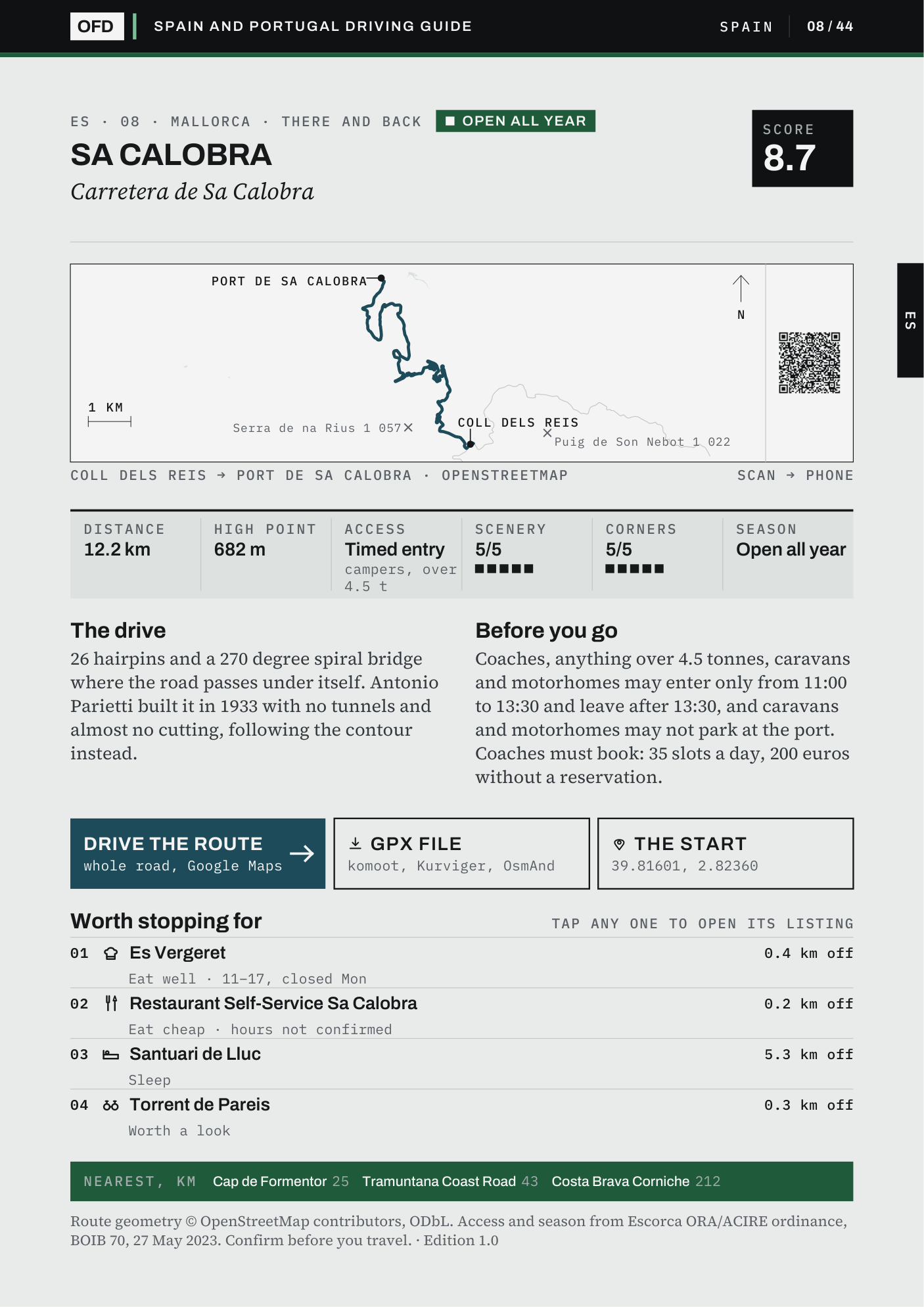
44 driving roads across the peninsula and Mallorca, one page each: what the road is like to drive, what stands between you and it in 2026, when you may drive it, up to four places worth stopping for, and a button that opens the whole route in Google Maps. 1,293 km of road, every line drawn from OpenStreetMap and measured against the towns its page names.
The gate is not a toll
None of the 44 roads charges a toll on the road itself; the nearest thing is the €1.50 Peneda-Gerês asks of a car crossing its forest in summer. What closes an Iberian road is a national park that bans cars for about six months, a landslide that shuts a pass from February to June, or a barrier below the summit that has stood since 1989. Each page says which.
Dates from the bodies that set them
Cap de Formentor is closed to private cars from 15 May to 18 October, 10:00 to 22:00, with fines of €100 to €200: that is the DGT's page and the Consell de Mallorca's notice, not a villa-rental site. The Covadonga lakes plan is the Principado's. Where a page's source is a travel site, the page says so.
A line measured against the towns it names
Every one of the 44 lines was measured against the endpoints printed under its map. Two stop short: the Dream Road before both its towns, and the Douro before Pinhão. Where the map and the road disagreed, the road won: the Velefique climb was drawn on the wrong road for three days before the extract said otherwise.
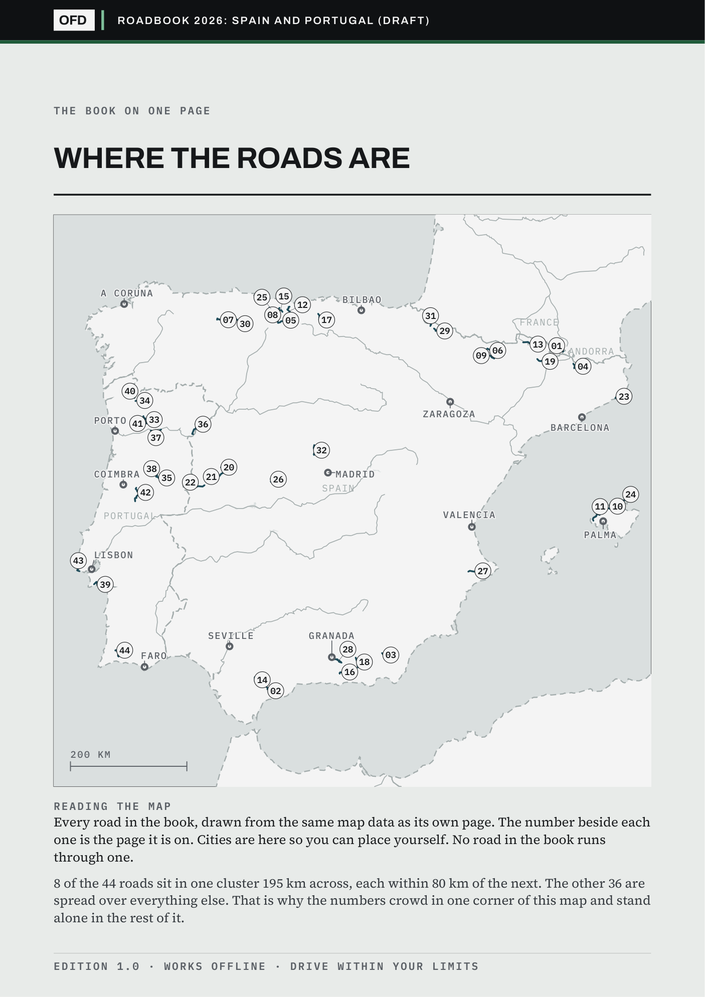
Page 2 of the guide
Check it is your region before you pay.
Straight-line distance from each city to the nearest point of each road. The free sample carries this whole map.
| City | Roads within 150 km | Nearest |
|---|---|---|
| Porto | 9 | 46 km |
| Coimbra | 7 | 25 km |
| Bilbao | 6 | 79 km |
| Granada | 5 | 4 km |
| Barcelona | 4 | 74 km |
| Palma | 3 | 14 km |
| Valencia | 1 | 86 km |
| A Coruna | 0 | 175 km |
Not your region? The shelf sorts all seven guides by the roads near your town.
The contents
Every road in the guide.
free in the sample
| No. | Road | Region | Toll or gate | Season |
|---|---|---|---|---|
| 01 | Ronda Road | Málaga | Shuts often | Open all year |
| 02 | Velefique | Almería | Free | Open all year |
| 03 | Creueta Pass | Catalunya | Free | Open all year |
| 04 | Añisclo Canyon | Aragón | One-way | Open all year |
| 05 | Somiedo and La Farrapona | Asturias | Free | Open all year |
| 06 | Valdeón Passes | Castilla y León | Free | Open all year |
| 07 | Sobrarbe Axis | Aragón | Free | Open all year |
| 08 | Sa Calobra free | Mallorca | Timed entry | Open all year |
| 09 | Tramuntana Coast Road | Mallorca | Free | Open all year |
| 10 | Hermida Gorge free | Cantabria | Roadworks | Open all year |
| 11 | Bonaigua Pass | Catalunya | Single lane | Open all year |
| 12 | Palomas Pass | Cádiz | Storm shut | Open all year |
| 13 | Cares Gorge to Sotres | Asturias | Summer bus | Open all year |
| 14 | The Alpujarras | Granada | Free | Open all year |
| 15 | The Dream Road | Cantabria | Free | Open all year |
| 16 | La Ragua Pass free | Granada | Free | Open all year |
| 17 | Canto Pass | Catalunya | Free | Open all year |
| 18 | Peña de Francia | Castilla y León | Free | Open all year |
| 19 | Las Hurdes | Extremadura | Free | Open all year |
| 20 | San Glorio Pass | Cantabria | Free | Open all year |
| 21 | Costa Brava Corniche | Catalunya | Free | Open all year |
| 22 | Cap de Formentor free | Mallorca | No cars | Seasonal car ban |
| 23 | Lakes of Covadonga | Asturias | No cars | Seasonal car ban |
| 24 | Pico Pass | Castilla y León | Free | Open all year |
| 25 | Guadalest Road | Alicante | Free | Open all year |
| 26 | Sierra Nevada Road | Granada | Barrier | Open all year |
| 27 | Irati Forest Road | Navarra | Paid parking | Open all year |
| 28 | Sierra de Gata | Extremadura | Free | Open all year |
| 29 | Pajares Pass | Asturias | Free | Open all year |
| 30 | Ibañeta Pass | Navarra | Free | Open all year |
| 31 | Navacerrada Pass | Madrid | Free | Open all year |
| 32 | The Minho Crossing | Norte | Free | Open all year |
| 33 | Zêzere Glacial Valley | Centro | Snow shut | Open all year |
| 34 | Douro River Road free | Norte | Free | Open all year |
| 35 | Torre Road | Centro | Snow shut | Open all year |
| 36 | Arrábida Escarpment | Setúbal | Free | Open all year |
| 37 | Gerês Park Road | Norte | Summer fee | Open all year |
| 38 | Alvão Mountain Road | Norte | Free | Open all year |
| 39 | The N2 over the Lousã | Centro | Free | Open all year |
| 40 | Douro Internacional | Norte | Free | Open all year |
| 41 | Sintra Coast | Lisboa | Free | Open all year |
| 42 | Monchique and Fóia | Algarve | Free | Open all year |
| 43 | Marão | Norte | Free | Open all year |
| 44 | Envalira Pass | Andorra | Free | Open all year |
Questions
Anything else: info@outforadrive.com
What does Edition 2027 mean?
You download the current guide the moment you pay, with every toll, gate hour and opening date as read for the 2026 season. Each is then checked again for 2027, and the rechecked edition is emailed to you free by 1 May 2027. The roads, routes and GPX tracks do not expire. Every guide, in the 2027 Edition (all seven guides in one checkout) or bought on its own, gets its rechecked edition this way.
What if a road is shut when I go?
Every page prints the road's season. Where the season has dates, the Start Here page on your phone checks today's date and says whether the road is open now, shut for winter, or which month it opens.
Does it work with my navigation app?
The GPX tracks load into komoot, Kurviger, Calimoto, OsmAnd and Garmin. If your car's own navigation cannot import a GPX file, tap Drive the route on the page: the whole road opens in Google Maps on your phone, and from there on CarPlay or Android Auto. Apple Maps and Waze get the start of the road.
Is it for motorcycles too?
Yes. The roads are the same on two wheels, and where an operator bars motorcycles, the road's own paragraph says so.
Is this a printed book?
No. It is a download: an A4 PDF with one page per road, a Start Here page for your phone that works with no signal, and a folder of GPX tracks. Print the PDF on a home printer if you want paper.
Can I give it as a present?
Yes. Buy it as usual, then write to info@outforadrive.com with the name and email address of the person it is for. A download link of their own is emailed to them, the licence passes to them, and the rechecked 2027 edition goes to their address too. Fresh links from the re-download page still go to the address you paid with.
What if it is not for me?
Ask for a refund within 30 days. One line is enough, and no reason is needed.
The 2027 Edition
This guide and six more for €79.00.
All seven cost €188.93 bought one by one. The 2027 Edition is one checkout for all of them and for every guide published while the 2027 Edition is on sale.
Every guide, in the Edition or bought on its own, gets its rechecked 2027 edition free by email.


