2026 edition · 21 of these 44 roads shut for winter from late October€26.99, once
Out for aDriveRoadbooks
ENDEBuy this book
Roadbooks  /  France Roadbook 2026
Out now · 2026 season

France Roadbook 2026

France, and the forty-four roads worth the detour

44 driving roads across France - the Alps north and south, Provence and the Verdon, the Pyrénées from the Atlantic to the Aude, the Cévennes, the Jura, the Vosges and Corsica - one page each: what the road is like to drive, who opens the gate and when, what you may not take up it, up to four places worth stopping for, and a button that opens the whole route in Google Maps. 1,332 km of road, every line drawn from OpenStreetMap and measured at both ends against the places its page names.

30-day refundDrive one road out of it. If it was not worth the Saturday, one line gets the €26.99 back and you keep the files.
Page 2 of 44 · the key map44 roads
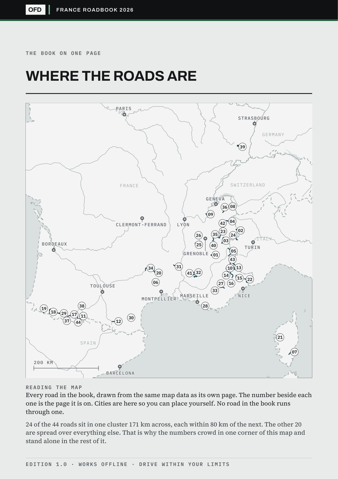
Page 2 of the book: every road on one plate, each marked with the page it is on, over country outlines
All 44 roads on one key map, each marked with its page. Drawn from OpenStreetMap. No photography.
France Roadbook 202644 roads · 1,332 km
€26.99Buy this book
44
Roads, one A4 page each
1,332 km
Measured on each road's own track
44
GPX tracks, one per road
167
Stops checked one by one, 9 left blank rather than guessed
Stage 01What page 01 does

The book opens on its best road, and prints what stands between you and it.

The Col du Noyer scores 10.0, which nothing in France beats, and it is page 01 because the book is ordered by country and then by score. Its page prints what stands between you and the road: the third cell reads “Cyclists only”, and the foot of the page names the body that says so.

Every other page is built the same way: the gate, the season, the measured distance and the source, before any adjective.

Roads marked shut
0 of 44
Roads with a toll
0 of 44
Facts without a source
none
Page 01 of 44 · as it printsOpen
Col du Noyer
Hautes-Alpes · 20.4 km · score 10.0
Cyclists only
AccessCyclists only
Route linkopens the whole road in Google Maps
GPX trackshipped
Source: alti-mag.com, printed in full at the foot of the page itself.
Stage 02The anatomy of one page · press it yourself

Seven things on every road's page.

01The drive scoreOut of ten, from corners, scenery and a traffic penalty. The formula is printed so you can disagree with it precisely.
02What stands between you and the roadA ban with dates, a barrier, a landslide closure or a toll, whichever it is, with the body that issues it.
03When the gate opensFirst and last admission, and the months the road is shut for winter.
04The distance, measuredTaken off the road's own GPX track, not copied from a tourist board.
05Up to four stopsEach checked one at a time. An empty slot stays empty rather than being filled with a guess.
06Drive the routeOne press opens the whole road in Google Maps, corner for corner, not just the start point.
07The sourceNamed at the foot of the page, so every number on it can be checked.
Page 13 of 44 · Cime de la BonetteLive · offline

Scroll it, press it. This is the page as it is in the book, at phone size.

Stage 03Before you pay · is it near you

Where these roads are, measured from where you start.

Grenoble has 22 of the 44 roads inside 150 km; Paris has none, and its nearest road is 361 km away. If you drive out of a city with many, this book is dense with Saturdays. If you drive out of one with none, it is a holiday purchase, and you should know that before you pay rather than after.

Every number is a straight line from the city to the nearest point of each road's own track, and the cities with none are printed alongside the cities with many.

Check your own town in the free sample
Starting fromWithin 150 kmNearest road
Grenoble22 roadsnearest 17 km
Turin19 roadsnearest 51 km
Geneva13 roadsnearest 33 km
Nice12 roadsnearest 24 km
Bordeauxnonenearest 194 km
Parisnonenearest 361 km
Six starting cities, measured in a straight line to the nearest point of each road's own track. The offline page re-sorts every road from whichever town you type into it.
Stage 04The index · check my work before you pay

Two of the 44, with their sources printed.

Both ends of what this book does: a road where whose third cell reads “Open 10-20” and a road where whose third cell reads “Shut on red”. Both carry the source of every figure on them, so a toll or a gate time can be checked before you spend anything. The free sample is the same two files cut to five roads, and it opens and closes on exactly these two.

PgRoadRegionLengthScoreAccess
13Cime de la BonetteAlpes-de-Haute-Provence / Alpes-Maritimes · 48.1 kmAlpes-de-Haute-Provence / Alpes-Maritimes48.1 km8.9Open 10-20
28Cap CanailleBouches-du-Rhône · 11.4 kmBouches-du-Rhône11.4 km8.2Shut on red
The other 42 are in the book.
Same page, same sources, one per road. Or take five roads free and check these two first.
Buy all 44 · €26.99
Stage 05Read this before you buy

What this book does not claim.

Somebody who read an early copy came away believing I had driven them all. I had not, and nothing in that copy had said so plainly enough. Four limits, each one open to read in full.

What €26.99 buys is desk research done properly and shown working: every fact carries its source, and the roads I could not verify say so on their own page.

01The book is in English

The road names print as the signs spell them, in French, and in Corsican and Basque where that is what the sign says; the prose is English.

02It is a book of the south and the east

France's driving roads are where its mountains are. Grenoble has twenty-two of these roads within 150 km, Turin nineteen, Geneva thirteen, Lyon and Nice twelve, Marseille ten. Paris has none within 300 km and its nearest is 361. If you are north of the Loire this is a holiday book, not a Sunday one, and the free sample draws all 44 on one map so you can see that before you pay.

03Five French roads are in the other books, not this one

The Col de la Faucille and the Forclaz with the Col des Montets are pages of the Switzerland book. The Agnello, the Lombarda and the Piccolo San Bernardo are in the Northern Italy book, drawn from the Italian side. Nothing is printed twice.

04Two of the forty-four are in Corsica

The Calanches de Piana and the Col de Bavella are worth the ferry, and the ferry is the honest part of that sentence: they are a crossing from Marseille, Toulon or Nice, not a detour.

The price

€26.99, once. All 44 roads, yours to keep.

One download of the 2026 edition, licensed to one person on any number of your own devices. No subscription, no account, no login. Find something wrong in it and it is fixed in the next edition. Buying this book does not commit you to the rest. All six books together are €79.00.

VAT included · checkout on Stripe · link by email in a minute
Refund within 30 days, one line, no reason needed, and you keep the files

What arrives
France-Roadbook.pdf44 road pages
France-Start-Here.htmloffline, one tap
gpx/44 tracks
Licenceone person, your devices
Page colour