2026 edition · 3 of these 50 roads shut for winter from late October€26.99, once
Out for aDriveRoadbooks
ENDEBuy this book
Roadbooks  /  Adriatic Roadbook 2026
Out now · 2026 season

Adriatic Roadbook 2026

Adriatic: from the Julian Alps to the Bay of Kotor
  • One A4 page per road
  • The same roads on your phone, offline
  • A GPX track for your navigation

50 driving roads across Slovenia, Croatia, Bosnia and Herzegovina and Montenegro - the Julian and the Kamnik-Savinja Alps, the Velebit and the Biokovo above the Adriatic, the islands, the canyons of the Neretva, the Drina and the Tara, Durmitor and the Bay of Kotor - one page each: what the road is like to drive, what stands between you and it and on what terms, up to four places worth stopping for, and a button that opens the whole route in Google Maps. 1,868 km of road, every line drawn from OpenStreetMap and measured at both ends against the places its page names.

30-day refundDrive one road out of it. If it was not worth the Saturday, one line gets the €26.99 back and you keep the files.
Page 02 of 50 · Vršič PassLive · offline

Scroll it, press it. This is the page as it is in the book, at phone size.

Adriatic Roadbook 202650 roads · 1,868 km
€26.99Buy this book
50
Roads, one A4 page each
1,868 km
Measured on each road's own track
50
GPX tracks, one per road
188
Stops checked one by one, 8 left blank rather than guessed
Page 01

The book opens on its best road, and prints what stands between you and it.

The Upper Savinja and Pavličevo Sedlo scores 8.9, which nothing in Slovenia beats, and it is page 01 because the book is ordered by country and then by score. Its page prints what stands between you and the road: its gate line reads “7.5 t limit”, and the foot of the page names the body that says so.

Every other page is built the same way: the gate, the season, the measured distance and the source, before any adjective.

Roads marked shut
0 of 50
Roads with a toll
1 of 50
Facts without a source
none
Page 01 of 50 · as it printsWinter: ask
Upper Savinja and Pavličevo Sedlo
Savinjska - Kamnik-Savinja Alps · 33.0 km · score 8.9
7.5 t limit
Access7.5 t limit
Route linkopens the whole road in Google Maps
GPX trackshipped
Sources: amzs.si · quaeldich.de · motorradonline.de · OpenStreetMap, printed in full at the foot of the page itself.
One page, seven things

Seven things on every road's page.

01The drive scoreOut of ten, from corners, scenery and a traffic penalty. The formula is printed so you can disagree with it precisely.
02What stands between you and the roadA ban with dates, a barrier, a landslide closure or a toll, whichever it is, with the body that issues it.
03When the gate opensFirst and last admission, and the months the road is shut for winter.
04The distance, measuredTaken off the road's own GPX track, not copied from a tourist board.
05Up to four stopsEach checked one at a time. An empty slot stays empty rather than being filled with a guess.
06Drive the routeOne press opens the whole road in Google Maps, corner for corner, not just the start point.
07The sourceNamed at the foot of the page, so every number on it can be checked.
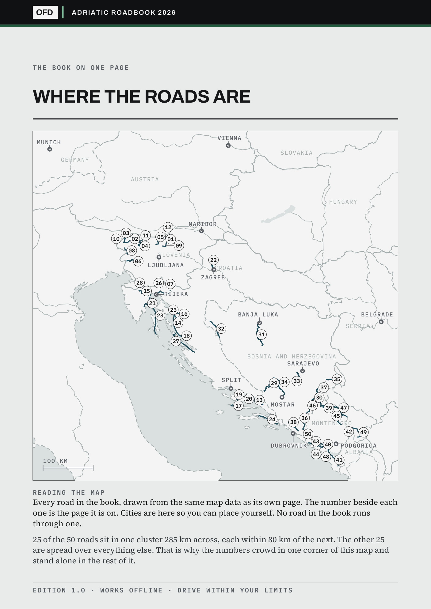
Page 2 of 50 · the key map50 roads
Page 2 of the book: every road on one plate, each marked with the page it is on, over country outlines
All 50 roads on one key map, each marked with its page. Drawn from OpenStreetMap. No photography.
Is it near you

Where these roads are, measured from where you start.

Dubrovnik has 25 of the 50 roads inside 150 km; Munich has none, and its nearest road is 244 km away. If you drive out of a city with many, this book is dense with Saturdays. If you drive out of one with none, it is a holiday purchase, and you should know that before you pay rather than after.

Every number is a straight line from the city to the nearest point of each road's own track, and the cities with none are printed alongside the cities with many.

Check your own town in the free sample
Starting fromWithin 150 kmNearest road
Dubrovnik25 roadsnearest 12 km
Rijeka24 roadsnearest 1 km
Mostar22 roadsnearest 3 km
Ljubljana21 roadsnearest 25 km
Viennanonenearest 236 km
Munichnonenearest 244 km
Six starting cities, measured in a straight line to the nearest point of each road's own track. The offline page re-sorts every road from whichever town you type into it.
Two pages, sources printed

Two of the 50, with their sources printed.

Both ends of what this book does: a road where whose gate line reads “Barriers” and a road where whose gate line reads “Park ticket”. Both carry the source of every figure on them, so a toll or a gate time can be checked before you spend anything. The free sample is the same two files cut to eight roads, and it opens and closes on exactly these two.

PgRoadRegionLengthScoreAccess
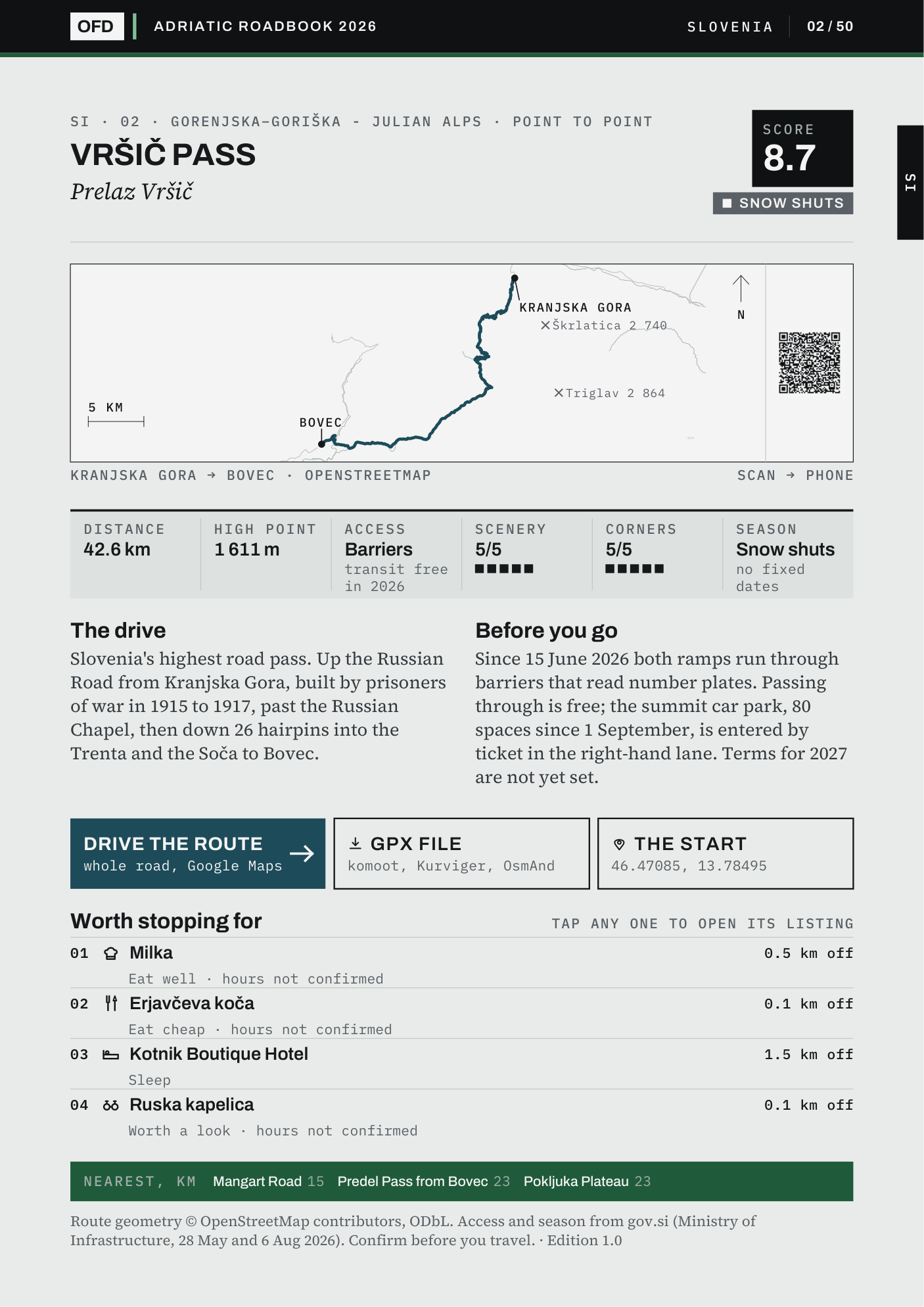
02Vršič PassGorenjska / Goriška - Julian Alps · 42.6 kmGorenjska / Goriška - Julian Alps42.6 km8.7Barriers
39The Sedlo PassŽabljak / Plužine - Durmitor · 46.9 kmŽabljak / Plužine - Durmitor46.9 km8.9Park ticket
The other 48 are in the book.
Same page, same sources, one per road. Or take eight roads free and check these two first.
Buy all 50 · €26.99
Read this before you buy

What this book does not claim.

Somebody who read an early copy came away believing I had driven them all. I had not, and nothing in that copy had said so plainly enough. Four limits, each one open to read in full.

What €26.99 buys is desk research done properly and shown working: every fact carries its source, and the roads I could not verify say so on their own page.

01The book is in English

The road names print as the signs spell them, in Slovene, Croatian, Bosnian and Montenegrin, with every mark on them; the prose is English.

02It is a holiday book from Vienna and Munich

Dubrovnik has 25 of these roads within 150 km, Rijeka 24, Mostar 22, Ljubljana 21, Podgorica 18, Sarajevo 16, Zagreb 15 and Split 13. Vienna and Munich have none within 150 km: the nearest is 236 and 244 km away. From Germany or Austria this is a holiday book, not a weekend one, and the free sample draws all 50 on one map so you can see that before you pay.

03The Italian and Albanian shores are not here

The Adriatic has two more countries on it. The Friuli passes are in the Northern Italy book; Albania is not in this series. Where a road here runs to the Italian, Austrian or Albanian border, the line stops at the frontier and the page names what is on the other side.

04Some of the best-known roads here are gravel

The road on to Zavižan above Oltari and the one on to Lukomir above Umoljani turn to gravel where these pages stop, and those pages say so. The Majstorska cesta over the Velebit and the Vrmac ridge above Kotor are gravel over their best stretches and are not in the book.

The price

€26.99, once. All 50 roads, yours to keep.

One download of the 2026 edition, licensed to one person on any number of your own devices. No subscription, no account, no login. Find something wrong in it and it is fixed in the next edition. Buying this book does not commit you to the rest. All seven books together are €79.00.

VAT included · checkout on Stripe · link by email in a minute
Refund within 30 days, one line, no reason needed, and you keep the files

Page 02 of 50Vršič Pass
One road page of the book: Vršič Pass
Page 02 of the Slovenia, Croatia, Bosnia-Herzegovina and Montenegro book, as it prints: the drive, the 2026 toll, the season, the stops and the route button. Every road gets one.
What arrives
Adriatic-Roadbook.pdf50 road pages
Adriatic-Start-Here.htmloffline, one tap
gpx/50 tracks
Licenceone person, your devices
Page colour