Roads
44
Germany, Austria, South Tyrol
44 driving roads, one page each: what the road is like to drive, this year's toll, when the gate opens, up to four places worth stopping for, and a button that opens the whole route in Google Maps. Checked for the 2026 season.
One of them is shut until 2030 and still ranks first in every search. The book opens on it, tells you not to drive it, and names the open road 33 km away instead.
One download, yours to keep. No subscription, no login. The free sample is 5 roads and 165 km in exchange for an email address.
Drawn from OpenStreetMap. No photography.
The hero above is a claim. This is the artefact: page 01, the first page a buyer opens, given to the one road they must not drive. Nothing on it was written for this website.
Closed since a rockfall and mudslide in July 2024 between hairpins 13 and 14, with further damage during 2025. There is no route link and no GPX file on this page on purpose: every routing app will still take you to the barrier.
A book that leads with a road it tells you not to drive is either honest or badly made, and you can tell which by looking at the page. That is the whole argument for the price, so it goes second, before any list of what you get.
One road ships no route link and no GPX file, which is why the pack holds 43 tracks rather than 44. The pack says so on this page rather than in a footnote.
What the road is like to drive, the 2026 toll, the season and the gate times, the route drawn from OpenStreetMap over a quiet basemap, and the source each fact came from, printed on the page rather than kept in a spreadsheet.
The Grossglockner button carries eight intermediate points, which is what stops it routing you round the mountain on the fast road. Apple Maps and Waze get the job they are good at: putting you at the start.
For komoot, Kurviger, Calimoto, OsmAnd or a factory nav. The shut road ships none: a track that ends at a barrier is worse than no track at all.
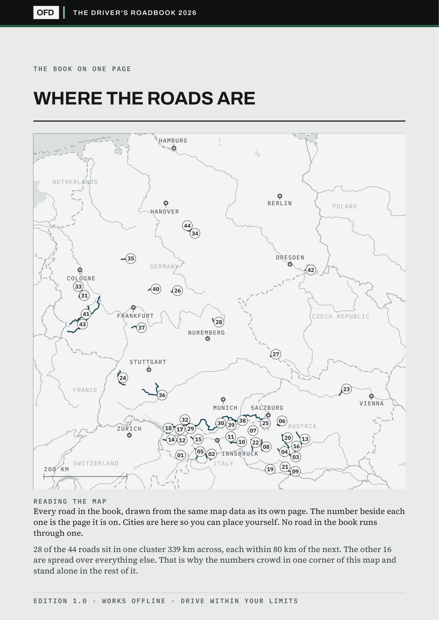
Page 2 is every road on one map, each marked with the page it is on. On the HTML page, type the town you are starting from and the list re-sorts nearest first. Both distances are straight lines rather than driving routes, and both say so where you read them.
Somewhere to eat well, somewhere to eat cheaply, somewhere to sleep, and something worth looking at. No road has none. Nothing here is paid for or affiliated.
The HTML page carries its own three typefaces and its own maps and opens from a file on the phone. There is no app, no account and no login, and neither file needs a network once it is on the phone.
A tank of fuel to reach a road that closed two years ago is the expensive mistake. So is 46.50 EUR at a toll booth you did not know about, or arriving at a pass gate an hour after it shut for the night.
Every page carries the three roads nearest it that are open, with the distance and the score, so one good road becomes a route.
A PDF and one HTML file. Open them from the phone in your pocket with no signal, no app and no account.
2026 tolls, gate times and closures, each with the source it came from printed beside it.
The Grossglockner, at the width you would read it on a phone. Press Drive the route and Google Maps opens the road, all 48 km of it. The four stops open their Google listings. Everything on it is the shipped file.
Page 08 of 44, whole
The Grossglockner, at the width you would read it on a phone. Press Drive the route and Google Maps opens the road, all 48 km of it, corner for corner. The four stops open their Google listings. Everything on it is the shipped file.
The most famous panoramic road in Austria and the most expensive in this list. 48 km, 36 bends, 2,504 m, through the Hohe Tauern National Park, carrying around 900,000 visitors a year. Go on a weekday at opening or accept coaches.
Toll 46.50 EUR per car for summer 2026, 42.50 EUR bought in advance online. Motorcycles 36.50 EUR, 33.50 EUR in advance. Gates open around 06:00 and stop admitting around 20:00.
Off the route. Nearest roads in the book, for a second day.
Route geometry © OpenStreetMap contributors, ODbL. Toll and season from grossglockner.at/en/for-your-visit/prices-opening-times. Confirm before you travel.
Edition 1.0 · Start 47.27598, 12.82637 · 08 / 44
Three changes for this page and no others: the GPX control is shown rather than wired, because the file is in the pack; the three roads at the foot link to pages that are in the pack, so they do not link here. Toll and season for this road come from grossglockner.at, printed on the page itself.
Three changes for this page and no others: the GPX control is shown rather than wired, because the file is in the pack; the roads at the foot link to pages that are in the pack, so they do not link here. Toll and season come from grossglockner.at, which is printed on the page itself.
Somebody who read an early copy came away believing I had driven them. That is the impression this section exists to prevent.
What is on these pages comes from maps, elevation profiles, curve counts, operators' own websites and other drivers' published accounts, read against each other and checked, not from a road test. That is what the drive score is for: comparing the roads with each other on one consistent scale. It cannot know the surface, the weather or the traffic on the day you go.
23 of those 25 are free public roads open all year: no toll to check and no gate to check it against. Two tolls are printed blank, on the Kaunertal Glacier Road and the Zillertal High Road, because I could not confirm the 2026 price. Blank is what an unconfirmed number looks like here.
Corners out of 5, plus four fifths of scenery out of 5, minus three fifths of a traffic penalty out of 2, rescaled to a mark out of ten. The formula is printed in the book so you can disagree with it precisely. All it guarantees is that it is wrong in the same direction for all of them.
28 of the roads sit in one cluster across the Alps and the pre-Alps. Innsbruck has 21 within 150 km, Munich 16, Frankfurt 8, Cologne 5. Hamburg and Berlin have none, and their nearest road is 189 and 186 km away.
What €26.99 buys is desk research done properly and shown working: every fact carries the source it came from, and the roads I could not verify say so on their own page. If that is not worth it to you, take the five-road sample and pay nothing.
Somebody who read an early copy came away believing I had. I had not, and nothing in that copy had said so plainly enough. The section above is what that question turned into, and the drive score page in the book now states its method rather than apologising for it.
Asked by a friend, and it is two questions rather than one. Page 2 of the book is now every road on a single map, each disc a link to that road's page. The HTML page answers the second: type the town you are starting from and all 44 re-sort nearest first. Neither existed a week before launch.
Both are in the edition you would buy, and in the free sample, which draws the same map of all 44 roads.
The sample is the same two files cut to five roads and 165 km. It opens on the Grossglockner, the page above, and it closes on the Silvretta, so you get both ends of what this book does in one download: a road that charges 46.50 EUR to drive it, and a road you should not drive at all.
Send one line within 30 days and you get the €26.99 back. No form and no reason needed. You keep the files.
The geometry is, and it is credited: the routes come from OpenStreetMap and the GPX tracks are yours to reuse under the same licence. What is not free is the day it takes to find out that the Silvretta is shut until 2030, that the Grossglockner is 46.50 EUR and shuts its gate at 20:00, and which four places near it are still trading. That is the part I did 44 times, with the source printed beside each answer.
No. Two files land in your inbox: a PDF and one HTML page that opens straight from the phone, offline, with its own maps and typefaces inside it.
That is the case it helps most. Type the town you land in and the list re-sorts nearest first, so a week of driving is planned before you collect the keys.
Tolls and gate dates are checked for 2026 and the source is printed beside each one. The roads, the routes and the GPX tracks do not expire.
Spain, Portugal and Andorra is in build now. Nine more are mapped and unbuilt, and you can tell me which one to build after that.
You can, and it will not break: A4, one road per page, no bleed off the edges. But it is built to be read at fit-width on a screen, and the buttons that open the route and the stops only work there. Print the pages for the weekend you are driving, and keep the file for the rest.
There is no way to prove research from the outside except by showing where it stopped. These are the four places this one stopped.
Four slots on each of the 44 roads. 169 of them print. The rest are empty because the place had closed, moved, or I could not confirm it was still trading, and an empty slot is a more useful thing to read than a guess.
1,902 km, measured against each road's own GPX track. Where a tourist board's figure and the measured one disagree, the measured one prints. So do the decimals: 39 of the 44 published lengths are round numbers and the roads are not.
The Kaunertal Glacier Road and the Zillertal High Road. I could not confirm the 2026 price, so there is no price. Blank is what an unconfirmed number looks like here, and it is the reason you can trust the other 42.
Printed at the foot of the road's own page, not kept in a spreadsheet I am asking you to believe in. Where the source is an operator's own site, it is named, so you can check me in one click.
One download of the 2026 edition. No subscription, no account, no login. A licence for one person on any number of your own devices.
This is edition one, published for the 2026 season. If you find something wrong in it, tell me and it is fixed in the next one: that is what the corrections address is for, and early buyers are the reason edition two will be better than this.
The download link arrives by email within a minute. Checkout runs on Stripe's own page, not here.
Rather try it first? Take five roads free
Payment runs through Stripe, and for this sale Stripe is the merchant of record. The roadbook itself is written, published and licensed by Tom Sonecki in Hamburg, a German Einzelunternehmen, and that is who you deal with for the files, the corrections and the refund.